GEOTECHNICALENGINEERING
BURLINGTON
HomeSeismicSeismic microzonation

Seismic Microzonation in Burlington, Ontario: NBCC-Compliant Site Response

Geotechnical engineering with regional judgment.

LEARN MORE

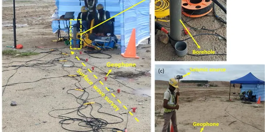
NBCC 2020 assigns seismic hazard values based on site class, and Burlington's soil profile across the Halton Region makes that classification far from uniform. The city sits on a mix of glaciolacustrine silty clays overlying Ordovician shale, with the Niagara Escarpment cutting through the northern edge. Site class can shift from C to E within a single city block depending on depth to bedrock and shear wave velocity. Our seismic microzonation work targets exactly that variability. We run MASW lines and SPT-based Vs correlations to develop continuous velocity profiles, then produce amplification maps tied to NBCC spectral acceleration values. For sites near the escarpment, we often combine seismic refraction with surface wave methods to confirm bedrock depth where topography complicates the survey.

Two sites 500 metres apart in Burlington can differ by two NBCC site classes, doubling the design spectral acceleration.

Our service areas

Methodology and scope

Comparing a site in Aldershot to one in downtown Burlington illustrates the range. Aldershot soils are thin, with shale bedrock often within 3 to 5 metres and Vs30 values above 760 m/s, placing them firmly in Site Class B or C. Downtown, particularly south of Fairview Street toward Lake Ontario, thick deposits of Halton Till overlain by Lake Iroquois silty clays push Vs30 down to 150-250 m/s, resulting in Site Class D or E. We capture these contrasts by gridding MASW profiles at 50 to 200-metre spacing depending on project scale. Each Vs profile is inverted with RMS error below 5% and validated against SPT blow counts where boreholes are available. The output includes site period, Vs30, and spectral amplification factors per NBCC Table 4.1.8.4. For critical infrastructure, we add passive-source arrays to resolve deeper velocity structure beyond 30 metres.
Seismic Microzonation in Burlington, Ontario: NBCC-Compliant Site Response
Technical reference — Burlington

Local considerations

In Burlington, we frequently see design teams default to Site Class C without verification, particularly for mid-rise structures along the Plains Road corridor. That assumption can be off by a full class. A site class D or E condition under NBCC 2020 carries amplification factors that increase short-period spectral acceleration by 30 to 50 percent compared to Class C. For a six-storey residential building, that difference flows directly into base shear and lateral system design. The deeper soft clay pockets south of the QEW, deposited during glacial Lake Iroquois, are the primary culprit. We've mapped areas where 15 metres of soft silty clay sit directly on shale, creating a strong impedance contrast that amplifies ground motion in the 0.5 to 2-second period range. Missing that means the structural design underestimates demand.

Need a geotechnical assessment?

Reply within 24h.

Email: contact@geotechnicalengineering.co

Applicable standards

NBCC 2020 (National Building Code of Canada, seismic provisions), ASTM D4428/D4428M-14 (crosshole seismic testing), ASCE 7-22 site classification (Vs30 framework), NEHRP site class definitions

Technical parameters

ParameterTypical value
MethodologyActive MASW (24-ch geophone spread), passive MAM, SPT-based Vs correlation
Vs30 range observed in Burlington150 m/s (downtown clays) to >800 m/s (Aldershot shale)
Site class per NBCC 2020 Table 4.1.8.4.AClass B through E mapped by zone
Depth of investigation (active)30–40 m typical, 60+ m with passive arrays
Grid spacing50 m (detailed) to 200 m (regional mapping)
Key output parametersVs30, T0 (site period), Fa/Fv amplification, NEHRP class
ValidationCross-check with SPT N60 where borehole logs available

Frequently asked questions

What is the typical cost range for a seismic microzonation study in Burlington?

For a Burlington site, seismic microzonation studies typically range from CA$4,980 for a single-family lot with one MASW line to CA$19,560 for multi-hectare commercial developments requiring gridded Vs30 mapping with passive arrays. The final cost depends on survey area, required grid density, and whether borehole SPT calibration is included.

How does NBCC 2020 use Vs30 for site classification?

NBCC 2020 Table 4.1.8.4.A classifies sites from A (hard rock, Vs30 > 1500 m/s) to E (soft soil, Vs30 < 150 m/s). The site class determines the spectral amplification factors Fa and Fv that modify the reference ground motion. In Burlington, the lacustrine clay deposits south of the QEW frequently produce Site Class D or E conditions requiring higher design forces.

What grid density do you recommend for a Burlington subdivision?

For subdivision-scale projects in Burlington, we recommend 100-metre grid spacing as a baseline, tightened to 50 metres where preliminary data shows rapid lateral variation, such as transitions from Halton Till to Lake Iroquois deposits. The grid is designed to capture the boundary between Site Class C and D/E with sufficient resolution for lot-level classification.

Do you need boreholes for a microzonation study, or can MASW stand alone?

MASW can provide standalone Vs profiles, but we strongly recommend at least two calibration boreholes with SPT N60 data in Burlington. The glacial stratigraphy here—particularly the contact between Halton Till and underlying shale—can produce velocity inversions that MASW alone may misinterpret. Borehole control anchors the inversion and improves Vs30 accuracy by 10 to 15 percent.

Location and service area

We serve projects across Burlington and its metropolitan area.

View larger map